Submitted on
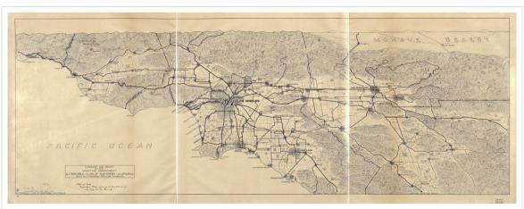
1915 MAPS OF LA - Courtesy of SoCaGIS.org
Notice the size of each town, they are tiny, no carpet of buildings like today.
Notice the Ballona Creek area has no streets!!!
Notice the LA River area has no streets!
Flooding preventing building near either the Creek or the River.
We include the flood zones somehow into the next iteration of presentations or maps? Is it worthwhile to do so? I ask, as I so enjoyed the two historical presentations. Developing some of our own History, to add to theirs, would show good will on our part, to the two gentlemen historians. This email might be forwarded to them?
Posted to SoCalGIS.org
which links to Library Of Congress (A wonderful resource!!!)
which links to actually full size image (2666x998 pixels):
Links for Top Horizontal Menu:
- 2674 reads